 Locating the Northern RoadLocating the Northern Road
Based on discussions with local residents and members of the Charlotte Historical Society, and after numerous trips through the underbrush in the area, members of the museum staff were able to locate the remnants of the old foundations of the bridge that once crossed the tracks. A survey marker was also found.
Trusting in Thompson's abilities as an astute observer and suspecting some other source to be the cause of the error, workers decided to use the ratio of 55 rods to 25 rods and apply it to the total distance. By using this 7:3 ratio, the distance from th e South Road to the discovery site was estimated to be 1797 feet (547.7 meters). This distance was measured and a marker placed to designate the spot.
The Charlotte Historical Society has a fine specimen of a Gunter Chain (#75/001/26) in their collection. They agreed to loan it to the museum to allow verification of the distance along the tracks to the whale discovery site.
Before beginning, the museum measured the Gunter Chain and found it to be 33 feet (10.1 meters), or exactly two rods, in length. Could it be that what Zadock Thompson was reporting in his articles was actually total lengths of the chain rather than "rods " as classically defined?
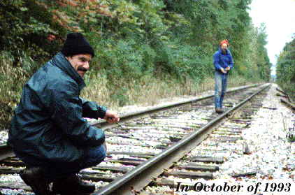 , members of the museum staff
returned to the tracks to take measurements with the Gunter Chain. The
distance between the Northern and Southern (Thompson's Point Road) roads was determined to be 77 lengths, or 2541 feet (774.5 meters). This compares favorably with the previous distance of 2567 feet measured with a steel rule.
, members of the museum staff
returned to the tracks to take measurements with the Gunter Chain. The
distance between the Northern and Southern (Thompson's Point Road) roads was determined to be 77 lengths, or 2541 feet (774.5 meters). This compares favorably with the previous distance of 2567 feet measured with a steel rule.
Using this method, the marker placed previously by applying the 7:3 ratio was found to lie 53.5 lengths north of Thompson's Point Road, and 23.5 lengths south of the Northern Road, very close to Thompson's reported distances in rods! It is apparen
t that Thompson was reporting his distances in total chain lengths, confusing them for "rods". We were now confident that we had homed in on the original discovery site to within 10-20 feet of its original location.
(Remember that distances may vary depending on whether one uses the center or edge of TPR (Southern Road) as a starting point for measurement, whether the exact location of TPR has changed, and whether one uses the implied center of the Northern Road o
r the survey marker located in the woods to the east of the tracks.)
Return to Directory of Exhibits or UVM Home Page.
__________________________________________________________________
Send questions, comments, changes, and additions to Wesley.Wright@uvm.edu and jefflhowe@verizon.net