 Current Research in the Field
Current Research in the Field
Current Research in the Field
" ...The distance between the two roads, which cross the railroad, one on the north and the other on the south side of the locality (discovery site), is about 80 rods; the distance to the locality, from the north road, being perhaps 25 rods, and from the south road, 55 rods. The northern road crosses he railway on a bridge, over the excavation, elevated about 16 feet above the track: the southern road crosses on a level with the track."
(NOTE: The "Southern" Road is now known as Thompson's Point Road.)
Notice from this sketch of the present configuration of the area in the vicinity of the whale discovery site that the road originally designated as the "Northern Road" in Thompson's 1853 account no longer exists. In order to precisely locate the discover y site, researchers needed to find the "Northern Road".
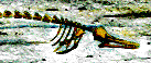
Museum workers knew that establishing the location of the original discovery site would not necessarily lead to finding more bones; however, it was now possible to look for other evidence that might lie at the same stratigraphic level. It was decided to r eturn to the site, move approximately 100 feet west of the tracks (to assure strata undisturbed by the railroad), and dig another hole.
Return to Directory of Exhibits or UVM Home Page.
__________________________________________________________________
Send questions, comments, changes, and additions to Wesley.Wright@uvm.edu and jefflhowe@verizon.net